


Mad Mutt Marine GPS Navigator

Descripción de Mad Mutt Marine GPS Navigator
I started writing this application as something that would be useful to me. Since that it has grown and I am rather pleased with it. It is an aid to marine navigation and must be used in conjunction with charts that are printed on that white stuff that is called (So I’m told) paper.
Features
•Designed by and for a sailor. You may find that some of the layouts look “big and blobby” at first sight, but they work at sea. Fiddly and fussy layouts do not.
•No network required. This app uses your phone’s GPS, it will work where there is no mobile network coverage (though you will need network coverage to share your logs and waypoints by email).
•Store unlimited waypoints (restricted in free version).
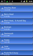
•View waypoints alphabetically of by distance from your current position.
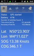
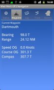
•Display range and bearing to a waypoint.
•Make logs of where you have been, which you can annotate with comments and other relevant data.
•View logs as display on the phone.
•Share logs with Google Earth on your phone or desktop computer, either by email or by copying KML files.
•Share waypoints with Google Earth on your phone or desktop computer, either by email or by copying KML files.
•Share logs with Google Earth on your phone or desktop computer, either by email or by copying KML files. Although I don’t encourage the use of Google Earth for marine navigation, seeing your waypoints on Google Earth is a useful visual check that you have transcribed them correctly.
•Anchor watch alarm service. Alerts you if you have moved more than a pre-defined distance. The anchor watch also alerts you if the battery level is low.
•Near waypoint alarm service
•Once started, the log, anchor and waypoint alarm services will continue to run, even if you quit the main navigator application. They will continue to run while you make phone calls or use your phone for email, Internet browsing or pretty much anything else.
What this application is not
It is not a chart plotter. This application is intended for marine navigation. Although it could be used by ramblers, that isn’t the main intention. It does not display digitised charts, nor does it show you a Google Map view with your position displayed on it. I believe it is highly irresponsible to encourage the use of Google maps to navigate boats. Even in rivers and estuaries, Google maps contain no semantics for the sea whatsoever; no lights and marks, depths, rocks etc. The application does allow you to send logs you have made to Google Maps, though, but only after you have completed the trip.
Free Version
For a limited time, a free version is available. In the Autumn of 2012 a full feature version should be available.
The free version has the following limitations:
•The number of waypoints you can have is restricted to 20.
•Routes are not availableEmpecé a escribir esta aplicación como algo que sería útil para mí. Desde que ha crecido y estoy bastante satisfecho con ella. Se trata de una ayuda a la navegación marina y debe ser utilizado en conjunción con las cartas que se imprimen en esa cosa blanca que se llama (Eso me han dicho) de papel.
Características
• Diseñado por y para un marinero. Usted puede encontrar que algunos de los diseños parecen "grandes y blobby" a primera vista, pero que trabajan en el mar. Diseños complicados y exigentes no.
• No se requiere de la red. Esta aplicación utiliza el GPS de tu teléfono, que funcionará cuando no haya cobertura de red móvil (aunque usted tendrá cobertura de la red para compartir sus registros o puntos de interés por correo electrónico).
• waypoints ilimitadas Store (restringidas en la versión gratuita).
• Ver waypoints Alfabeto por distancia desde su posición actual.
• Gama de la exhibición y el cojinete a un waypoint.
• Hacer los registros de dónde ha estado, que puede anotar con comentarios y otros datos relevantes.
• Ver los registros como la visualización en el teléfono.
• Compartir los registros con Google Earth en tu teléfono o computadora de escritorio, ya sea por correo electrónico o copiando los archivos KML.
• Compartir los waypoints con Google Earth en tu teléfono o computadora de escritorio, ya sea por correo electrónico o copiando los archivos KML.
• Compartir los registros con Google Earth en tu teléfono o computadora de escritorio, ya sea por correo electrónico o copiando los archivos KML. Aunque yo no aliento el uso de Google Earth para la navegación marina, viendo tus waypoints en Google Earth es un control visual útil que usted los ha transcrito correctamente.
• Servicio de alarma de fondeo. Le avisa si se ha desplazado más de una distancia predefinida. El fondeo también te avisa si el nivel de batería es bajo.
• Servicio de alarma Cerca waypoint
• Una vez iniciado, el registro, el ancla y servicios de alarma waypoint seguirán funcionando, incluso si sale de la aplicación principal del navegador. Ellos continuarán ejecutándose mientras realiza llamadas telefónicas o utilizar el teléfono para correo electrónico, navegación por Internet o casi cualquier otra cosa.
Lo que esta aplicación no es
No es un plotter. Esta aplicación está destinada para la navegación marítima. A pesar de que podría ser utilizado por los senderistas, que no es la intención principal. No muestra los gráficos digitalizados, ni le muestran una vista Google Map con su posición mostrada en él. Creo que es muy irresponsable para fomentar el uso de los mapas de Google para navegar los barcos. Incluso en los ríos y estuarios, los mapas de Google contienen semántica para el mar que sea; sin luces y marcas, profundidades, rocas, etc La aplicación permitirá enviar los registros que ha realizado en Google Maps, sin embargo, pero sólo después de haber completado el viaje.
Versión Gratuita
Por un tiempo limitado, una versión gratuita está disponible. En el otoño de 2012 una versión completa función debe estar disponible.
La versión gratuita tiene las siguientes limitaciones:
• El número de waypoints que puede tener se limita a 20.
• Rutas no están disponibles
Mad Mutt Marine GPS Navigator - Versión 1.07
(04-08-2014)
Mad Mutt Marine GPS Navigator - Información de APK
Version de la app: 1.07Paquete: uk.ac.plymouth.madmutt.gpsnavigatorÚltima versión de Mad Mutt Marine GPS Navigator
Otras versiones


Apps en la misma categoría

Quizá también te interese...


